Xidang to Upper Yubeng
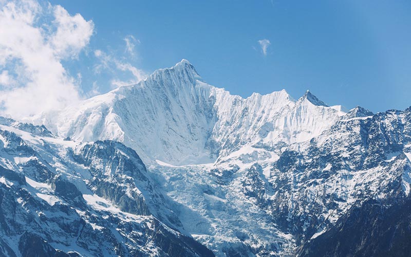
Over the 3,700 m pass and down through the forest — the arrival walk, with the mountain revealing itself at the pass.
 Start your enquiry
Trekking / Yubeng · The pilgrimage loop
Yubeng is the village the road forgot — a valley under the unclimbed Kawa Garpo where every trail is a pilgrim trail, every waterfall a prayer, and the walking is the worship.
Start this route briefYunnan · Under the Meili snow mountains
Kawa Garpo, the main summit of Meili — never climbed, respected by law and custom, and the entire valley's reason for being
of trail down from the Xidang hot springs — the road stops there, and the village keeps its cars outside
the day walk to the Sacred Waterfall and back through the great moraine amphitheatre — the inner pilgrimage
the long day up the glacier valley to Ice Lake at about 3,850 m, past the Smile Farm base camp meadows
Yubeng sits in a hanging valley at 3,200 metres directly under the east face of Kawa Garpo, and for centuries the only way in was on foot — a mule trail over a 3,700-metre pass from the highway, or up the Ninong gorge from the river below. The village is two hamlets, Upper and Lower Yubeng, split between farm fields and prayer walls, and the paths from them are the pilgrim routes around the sacred mountain's inner country.
The classic loop is four days: in over the Xidang pass, a day to the Sacred Waterfall, a day to Ice Lake, and out down the Ninong gorge — a walking circuit that never repeats itself and never leaves the mountain's shadow. This page walks it stage by stage; the valley's background and practicalities live on the main Meili page.
One context note that matters: 2026 is a horse year in the Tibetan calendar, the zodiac year of Kawa Garpo himself, and the pilgrimage trails will carry far more Tibetan walkers than usual — which is neither a problem nor a performance, but the whole point of the valley. Plan beds early, and walk with the crowds, not around them.
Four walking days that make a complete circle of the sacred valley.
Over the 3,700 m pass and down through the forest — the arrival walk, with the mountain revealing itself at the pass.
The inner kora: out through the moraine amphitheatre, under the ice wall, to a fall that pilgrims walk three times around.
The valley's long day: up the glacier trough past the base-camp meadows to a grey-green lake under the icefall.
The gorge descent to the river road — a different country from the entry, and the loop's closing argument.
The trail climbs steadily from the road end through oak and pine forest, the switchbacks mercifully cool. At the pass, prayer flags and the first full look at the Meili wall.
A forest descent to the village gate. Arrive by lunch, take a farmhouse room, and spend the afternoon walking the village's own circuit of prayer wheels and fields.
The pilgrim highway: out through the fields onto the moraine, past the great chorten, into the amphitheatre under the peak. The fall drops from the ice; pilgrims circle it; everyone gets wet in the spray. Return by the same path in evening light.
Up the lateral valley past Lower Yubeng and the Smile Farm meadows — the old base-camp site — climbing the old moraine to the lake at 3,850 m, grey-green and calving gently under the icefall. Long, gentle, enormous.
The exit: a sustained descent as the valley walls close in, past waterfalls and a hot spring, to the river road and the waiting vehicle. The gorge is the loop's surprise — subtropical, loud with water, a different country.
From the road end it is a short drive to Feilai Temple for the sunset view of the whole range — the mountain seen whole at last, from outside.
The loop is moderate walking at real altitude: nothing technical, but three consecutive days between 3,200 and 3,900 metres. Take the arrival day easy, drink more water than feels reasonable, and let the village's pace set yours — this is a pilgrimage valley, and it rewards slowness.
Accommodation is farmhouse guesthouses, warm enough and honest; the mule trains that carry luggage are part of the valley's economy, and hiring one helps both your knees and the village. Book ahead in the horse year — the valley has a finite number of beds and an infinite draw.
And walk it with the mountain's standing: Kawa Garpo is unclimbed by decision, protected since 2000, and the valleys below are working farmland and sacred ground. The trails are shared with pilgrims for whom this is devotion, not scenery — give way at the chortens, walk the kora clockwise, and leave the spray on the waterfall where it belongs.
May to June for rhododendrons, September to October for clear skies; the horse year will be busy all season.
The village is at 3,200 m and the lake at 3,850 m — one easy arrival day is the best altitude medicine there is.
Farmhouse guesthouses in both hamlets; beds, not hotels, and that is the valley's charm. Reserve early.
Xidang is an hour from Feilai Temple and Deqin; the Ninong exit lands on the river road for the return.
The mule carries the rest.
The Sacred Waterfall falls from the ice wall in a single white column, and around its pool the pilgrims walk — three circuits, prayer wheels turning, older women in the spray laughing. The path they walk is worn into the moraine like a groove in wood.
You may walk it too; you will be invited to. The circuit is clockwise, the direction of all kora, and three times around takes perhaps twenty minutes and rearranges something. The mountain above — the east face of an unclimbed 6,740-metre peak, vertical for two kilometres — watches the whole time.
That is the valley's real itinerary: not the lake, not the pass, but the twenty minutes at the waterfall where the walking and the worship turn out to be the same motion. Walk the loop and you will understand why the road never came.
In Yubeng the trail is the temple and every step is clockwise.
We run the Yubeng loop as a supported four-day circuit — farmhouse beds reserved, mules arranged, transfers at both trailheads — usually as part of a NW Yunnan line that includes Lijiang, the gorge and the Meili viewpoints.
The Yubeng valley guide · The Meili range guide · The NW Yunnan hub · The gorge high trail
Start a route brief