
Trekking routes / The Xiata valley & Muzart glacier
Private guided trek
Xiata Valley & the Muzart Glacier: 6 Days
The Xiata valley runs west to east out of Zhaosu county, straight at the highest wall of the Tianshan: Khan Tengri, the Muzart glacier, and the pass that the monk Xuanzang crossed in the 630s on his walk to India — he called it a mountain of ice that reaches to the sky. This trek follows the valley to the glacier's snout and back: five walking days, hot springs on the middle night, and the full crossing's scenery at a fraction of its commitment.
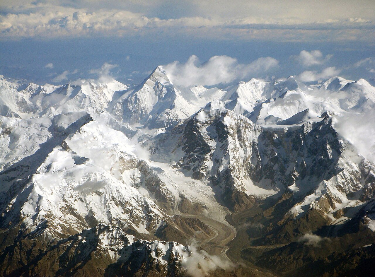
Ask about this itineraryThe Khan Tengri wall at the head of the Muzart valley — the pass Xuanzang called the mountain of ice
a valley glacier falling from the Khan Tengri massif; its snout sits a half-day's walk above the hot springs, close enough to hear the meltwater moving under the ice
the high point of the trek's turn-around ridge — the full crossing continues over the Muzart pass to Aksu, a serious mountaineering route we do not offer as a trek
Zhaosu is the home of the Ili horse — the Wusun's 'heavenly horses' — and the valley camps still move with the herding calendar
June has the flowers, August the warmth and the afternoon storms, September the clear light; the valley is snowbound and closed the rest of the year
Why this route
Xuanzang's mountain of ice, without the crossing.
The full Xiata crossing — over the Muzart pass to the Aksu side — is a genuine mountaineering expedition, glaciated and occasionally closed for years at a time. The valley walk, mercifully, is not: it follows the forested valley floor past herder camps and hot springs to a moraine amphitheatre under the icefall, sleeping each night in or near camp at elevations that let you actually recover. You get the glacier at eye level, the great wall of the Tianshan overhead, and the valley's deep history — this was one of the silk road's real crossing points, graded by monks and caravans rather than engineers.
It is the ideal first Tianshan trek: real camping, real altitude, real weather, and an exit route down the valley the whole way. Pairs beautifully with the Kalajun grasslands to the east — same county, different world.
Route Briefing
In from Yining to Zhaosu and the Xiata valley roadhead; four walking days up the valley through forest, hot springs and moraine to the glacier viewpoint camp; return the same line, out via Zhaosu to Yining.
- undefinedundefinedundefined
- undefinedundefinedundefined
- undefinedundefinedundefined
- undefinedundefinedundefined
- undefinedundefinedundefined
- undefinedundefinedundefined
The Trek
Six days up the valley of ice.
A deliberately simple shape — up, up, look, down, out — because the point of this trek is to spend three nights deep enough in the valley to see the mountain change its moods.
-
Day 01
West to Zhaosu
Yining → Xiata roadhead
Meet in Yining and drive south-west through the Ili's farmland belt to Zhaosu county, the wettest, greenest corner of Xinjiang — then on up the Xiata valley to the roadhead and the park gate. First night in a valley guesthouse; gear sort with the mule team in the evening.
-
Day 02
Forest, bridges, and the first sight of ice
Roadhead → hot springs camp
Follow the valley track upstream through dense spruce, over log bridges and past the karahouses where herders summer, to the hot springs camp at about 2,400 m. Soak; on a clear evening the first view of the white wall at the valley head appears above the trees.
-
Day 03
Onto the moraine, 3,200 m
Springs → moraine camp
The valley narrows and the track gives way to moraine paths — a steady climb past the terminal lake to a camp on the grassy moraine island below the icefall. This is the trek's high camp and its most dramatic: tents on green, ice on every side, and the sound of the glacier working all night.
-
Day 04
The ice wall at eye level
Moraine → glacier viewpoint
A day walk without full packs to the viewpoint under the Muzart icefall at about 3,760 m — close enough to see the blue in the seracs and the meltwater streams appearing from under the snout. The guide reads the glacier's history from the moraine loops; lunch with the whole wall in view; back to the same camp for a second night.
-
Day 05
Down through the flowers
Moraine → springs → valley
Descend the valley the same line, with a long lunch stop at the hot springs, to a camp in the lower forest. Faster walking, warmer air, and the last evening camp of the trek.
-
Day 06
Out and away
Valley → Zhaosu → Yining
A short morning walk to the roadhead, then the drive back through Zhaosu — with time for the grassland stone figures and the horse country en route — to Yining by evening for onward flights. Or continue east to the Kalajun grasslands: the two treks share a county and combine into a ten-day Ili itinerary.
What's included
What is included, and what is not.
The valley walk runs light but supported — mules carry the camp, and the guide team knows the valley's weather and closure rules.
Included
Arranged and paid in your price.
-
L
o
-
A
l
-
H
o
-
A
c
-
G
r
Not included
Either yours to arrange, or a question we will gladly answer.
-
F
l
-
S
l
-
T
r
-
H
o
-
T
i
Said plainly: the full Muzart crossing to Aksu is a glaciated mountaineering route, not a trek, and is closed in some seasons entirely. This itinerary deliberately turns back at the glacier viewpoint. Valley access policy can change season to season; we confirm the current situation at enquiry.
Enquiry
Ask about the valley trek.
Tell us your dates and trekking background. We will come back with the season's access status, a packing list and a written route plan with a price.
- Difficulty
- Moderate — one high camp
- Best window
- Jun – Sep
- Group size
- 2 – 10, private departures
- Cost guide
- From ¥9,800 per person, twin share
Enquiry sent
Thank you — your enquiry is with us.
We reply within one business day. A copy of what you sent has gone to your inbox.
Need to add something? Write to inquiry@chinadventure.com.
Back to the itineraryRead next