
Trekking routes / The Wusun ancient trail
Private guided crossing
The Wusun Ancient Trail: 8 Days Across the Tianshan
Two thousand years ago the Wusun confederation bred its famous horses on the Ili side of the Tianshan and traded across the range into the Tarim basin. The trail their riders used still exists — a 120-kilometre line from the Kazakh village of Qiongkushitai, over the Baozha pass, down through spruce forest and a river canyon, past the impossible blue of Paradise Lake at 3,000 metres, over a second pass, and out to the desert rim at Heiyingshan. It is one of the great crossings left in China, and one of the least forgiving.
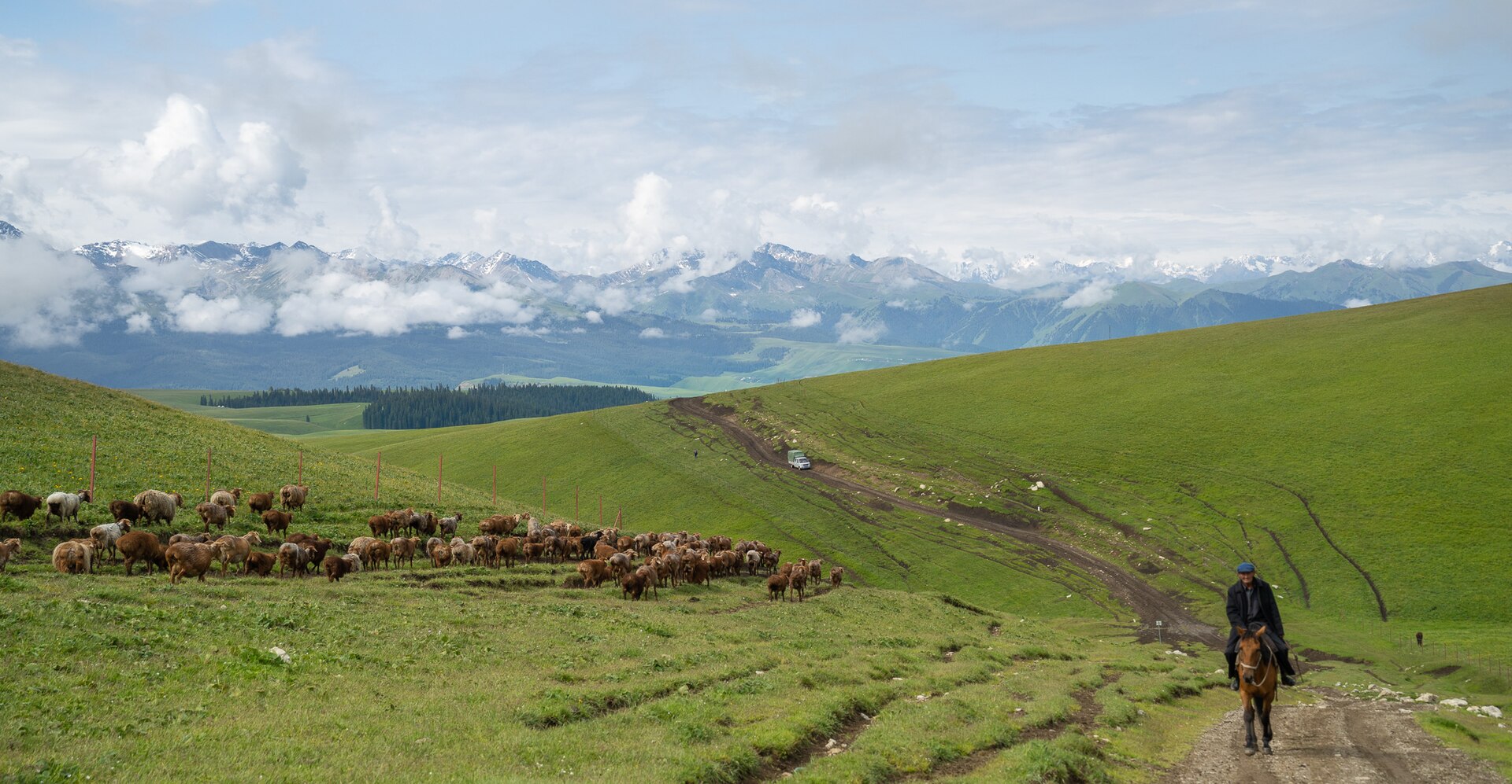
Ask about this itineraryThe Ili grasslands, where the trail begins — two thousand years ago this was the Wusun horse country
Paradise Lake (Akbulak lake) sits in a granite bowl, a blue so saturated that many trekkers reroute their whole summer around a single morning beside it
Baozha pass on the north side, Akbulak pass — the high point — on the south; both are steep scree with early-season snow
the crossing's defining hazard: a milky glacial river crossed several times, highest water mid-afternoon, which is why every day here starts early
the passes hold snow until June and the river runs heaviest in August; September is the connoisseur's month — stable weather, low water, and larch colour
Why this route
The old horse road over the wall.
The Tianshan is not a range you go around — for two thousand years you went over, and the Wusun trail was the horse route: graded by hooves, marked by graves, linking the Ili grasslands to the oasis kingdoms of Kuqa and Baicheng. Walking it is a compressed history of the region — Kazakh summer pastures, Kirghiz herder camps, the rusted cableway where herders still cross the Kokesu with their sheep, and the ancient pass cairns at the top of the scree.
It is also, said plainly, a serious route. There are two high passes, multiple glacial river crossings, and no road access for six days — the route's own guides call it high-risk in the wrong conditions. We run it with an experienced local guide team, full mule support, wading shoes for every crossing and a satellite phone. If you want the Tianshan crossed properly, this is the way it gets crossed.
Route Briefing
In from Yining through the old town of Tekes, over the Baozha pass, down the Kokesu canyon, past Paradise Lake, over the Akbulak pass and out through the Boz-Kirghiz river valley to Heiyingshan and Kuqa. One direction only — the south side is graded gentler this way round.
- undefinedundefinedundefined
- undefinedundefinedundefined
- undefinedundefinedundefined
- undefinedundefinedundefined
- undefinedundefinedundefined
- undefinedundefinedundefined
- undefinedundefinedundefined
- undefinedundefinedundefined
The Crossing
Eight days, north to south.
Distances are honest and the days are full — this is a crossing, not a stroll with a view. Camps sit on herder ground, and the mule team moves faster than you on anything flat.
-
Day 01
Into the Ili, over the Eight Trigrams
Yining → Qiongkushitai
Meet in Yining, drive east through the Ili valley to Tekes — the county town laid out as a giant bagua, or eight-trigram wheel, with radial streets and no traffic lights worth the name — then up the valley to Qiongkushitai, a wooden Kazakh village at 1,950 m at the trailhead. Evening walk on the pastures, gear check with the mule team, and an early night in a homestead.
Meeting point note: Yining has direct flights from Urumqi and Xi'an; most travellers overnight in Urumqi and connect the same morning.
-
Day 02
Spruce forest and the first climb
Qiongkushitai → valley camp
Cross the village bridge and follow the Qiongkushitai river upstream through dense Schrenk spruce — some of the finest forest in the Tianshan — climbing steadily to a herder camp on a river flat at about 2,450 m. Ten gentle kilometres that feel like a warm-up act, which is exactly what they are.
-
Day 03
The Baozha pass, 3,660 m
Valley camp → KounuSay camp
The first hard day: a long scree ramp to the Baozha pass at 3,660 m, cairned and snow-patched until late June. The reward is the view south — range after range of the central Tianshan, and the V of the Kounusay valley falling away below. Descend to camp near 3,050 m. Start early; the pass generates its own weather by afternoon.
-
Day 04
Down to the great river
Kounusay → Kokesu canyon
A long descent through the gorge system to the Kokesu river — a drop of a thousand metres into canyon country, past cliff swallows and the first roadside shrine cairns. Cross at the herders' crossing point and camp near the rusted cableway at about 2,000 m, the crossing's lowest and warmest night. Wading shoes on; the river is the boss here, and the guide reads its morning level before anyone steps in.
-
Day 05
Up to the blue, 3,000 m
Kokesu → Paradise Lake
Follow the south bank upstream into the Akbulak valley, climbing through open meadow country to the moment every photo of this trail is built on: Paradise Lake — Akbulak lake — appearing at the head of the valley, an unnatural slab of blue under granite walls. Camp on the shore pastures at 3,000 m. Afternoon free for the lakeshore; the light at dusk turns the water electric.
-
Day 06
The high point, 3,890 m
Paradise Lake → Akbulak pass
Round the lake on the shepherds' ledges and climb the long scree to the Akbulak pass at 3,890 m — the crossing's summit, usually patched with snow. The south side drops over a thousand metres into the Boz-Kirghiz river country; camp in the upper valley. This is the day your fitness was built for.
-
Day 07
The long walk out
Boz-Kirghiz valley → Heiyingshan
Down the Boz-Kirghiz valley on herder and jeep tracks — a long, hot, low-altitude day through red rock country that already feels like the Tarim basin. At the Heiyingshan trailhead the 4WDs are waiting; drive out to Baicheng county and on to Kuqa by evening for the first proper bed in a week.
-
Day 08
Oases, and the caves if you can
Kuqa — depart
Depart from Kuqa — with time for the Kizil caves or the grand canyon if your flight allows, both half-hours away and both worth a day. Or continue west: the silk oases journey picks up exactly here, and the two make a natural pair.
What's included
What is included, and what is not.
A crossing this remote runs on its support team: mules, cooks and guides who know the river's moods, plus the paperwork that gets a private group through the checkpoints and closures honestly.
Included
Arranged and paid in your price.
-
E
x
-
F
u
-
A
l
-
R
i
-
S
a
-
T
r
-
A
c
Not included
Either yours to arrange, or a question we will gladly answer.
-
F
l
-
S
l
-
T
r
-
T
i
-
O
p
Said plainly: this is a demanding route — river crossings in glacial meltwater, two passes near 3,900 m, and six days with no vehicle access. It suits trekkers with multi-day camping experience and good fitness. Access policy on the Wusun trail changes season to season; we confirm the current situation at enquiry and never run it against a closure.
Enquiry
Ask about the crossing.
Tell us your trekking background and target month. We will come back with an honest assessment of the season — river levels, pass snow and the current access situation — and a route plan with a price.
- Difficulty
- Demanding — passes and river crossings
- Best window
- Jun – early Oct; September prime
- Group size
- 4 – 10, private departures
- Cost guide
- From ¥13,800 per person, twin share
Enquiry sent
Thank you — your enquiry is with us.
We reply within one business day. A copy of what you sent has gone to your inbox.
Need to add something? Write to inquiry@chinadventure.com.
Back to the itineraryRead next