East Peak
The highest summit, reached from the Jinhekou trailhead in 5 to 7 hours. The top is a grassy dome with a survey marker, a view west into Shanxi, and the whole plateau of the Taihang laid out below.
 Start your enquiry
Destinations / Hebei / Xiaowutai Shan
Five summits on the highest massif in the province, 2,882 metres at the East Peak, inside a national nature reserve for the brown eared pheasant — and the one place in Hebei where a day’s walk runs from oak forest to alpine meadow.
Explore the guide ↓North-western Hebei · Yu County · 2,882 m
Xiaowutai is a massif of five summits — East, West, South, North and Central — in Yu County near the Shanxi border, formed in the Yanshan orogeny and built of limestone, shale and volcanic rock. The East Peak is 2,882 metres, which makes it the highest point in Hebei and, more to the point, the highest ground in the 500 kilometres between Beijing and the Yellow River.
What makes it worth the walk is the vertical sequence. In 1,500 metres of ascent the vegetation runs through six belts: farmland and secondary scrub at the foot, oak and pine forest, mixed broadleaf, birch and larch, conifer, and finally sub-alpine meadow with low juniper and gentian above 2,400 metres. That is a mountain flora compressed into a day’s walking, and the reason botanists have counted more than a thousand vascular plant species on the massif.
It is also a reserve, created for the brown eared pheasant — a large, dark, chicken-like bird endemic to the mountains of north China, hunted for its tail feathers and reduced to a few thousand birds. The core zone is closed; the walking is in the experimental zone and on the marked routes, with a permit, and the rules are enforced.
The summits, the belts, and the birds.
The highest summit, reached from the Jinhekou trailhead in 5 to 7 hours. The top is a grassy dome with a survey marker, a view west into Shanxi, and the whole plateau of the Taihang laid out below.
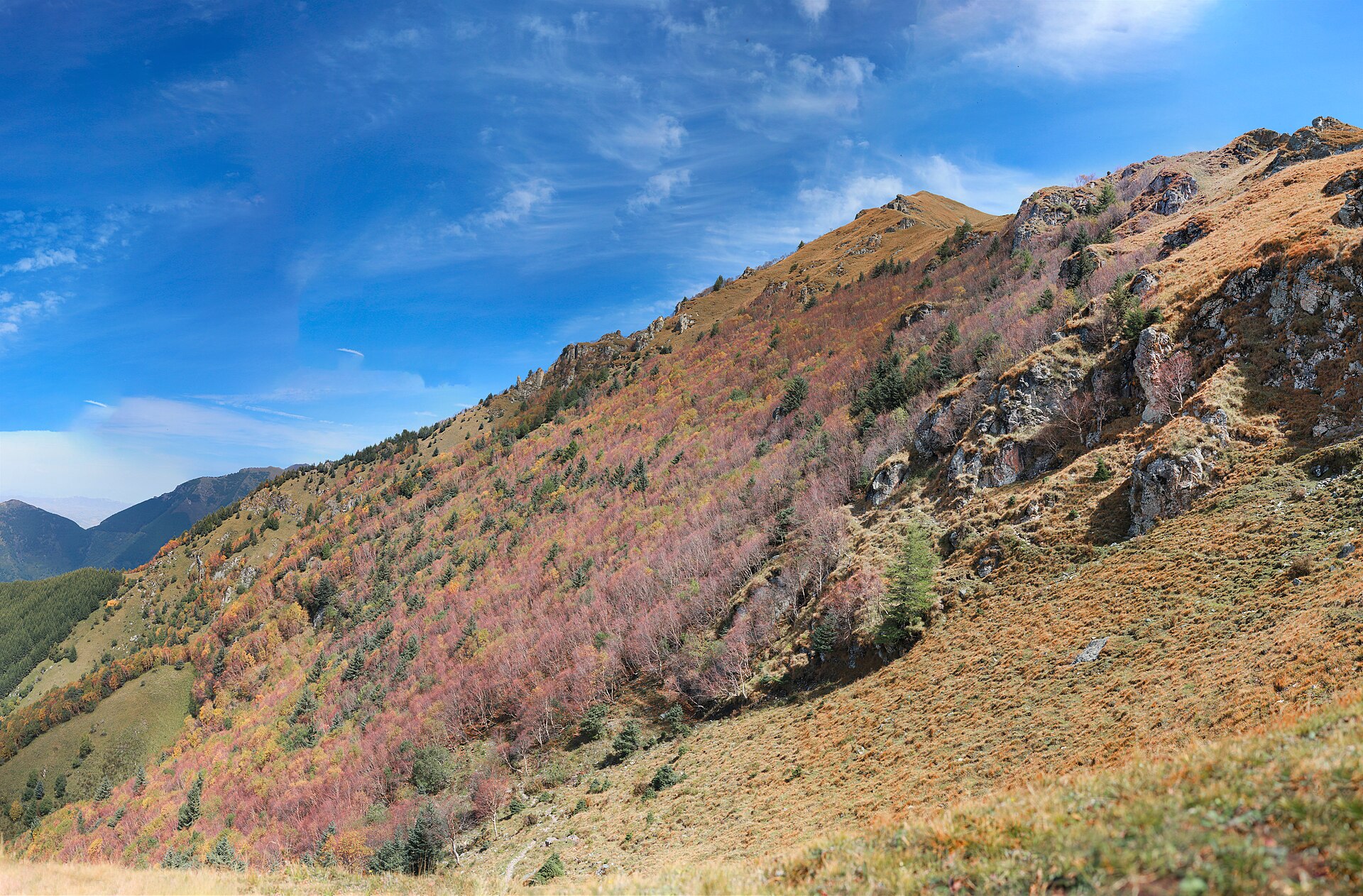
Six vegetation belts in one climb, from oak and pine at 1,200 metres to juniper and alpine meadow above 2,400. The birch and larch belt at 1,800 to 2,200 is the most colourful in October.
The western summit, lower and quieter, with a broad alpine meadow on its shoulder and the best gentian in late July. The photograph above is from its upper slope.
A bird the size of a small turkey, dark brown with white tail feathers, endemic to these mountains. Best chance is at dawn in the birch belt in April and May, and even then it is a glimpse.
The main trail from Jinhekou village: 1,100 metres of ascent to the East Peak, 5 to 7 hours up, 4 down, with two stream crossings and a forest camp at about 1,800 metres.
The alpine meadow above 2,400 metres flowers late: primula, gentian, buttercup and the yellow poppy of north China, peaking in the first half of June, a month after the plain.
June to early October; the meadow flowers in June, the larch in October.
The best months for the flowers and the birds: the forest belt is green, the meadow is blooming by early June, and the days are long. Nights still below freezing above 2,400 metres.
The rainy season: warm, wet, with afternoon storms on the ridge and leeches in the birch belt. The mountain is at its greenest and its most dangerous for a summit attempt.
The best window for the summit: dry, clear, cold at night, with the birch and larch turning gold from the last week of September. Snow can fall from mid-October.
The high routes close under snow and the reserve restricts access. The lower valleys remain walkable; the summits do not, and the road to Jinhekou can be blocked.
Two days for the summit, one for the lower belts.
Jinhekou at 1,100 metres to the East Peak at 2,882: 1,780 metres of ascent, 5 to 7 hours up, 4 down, on trail with two stream crossings. Start at first light; the afternoon storms are reliable in summer.
A forest camp at about 1,800 metres on the Jinhekou route, or a guesthouse in the village. Above that there is no shelter and no water after the last spring at 2,200 metres.
Xiaowutai is a national nature reserve: entry needs a permit arranged in advance through the reserve station at Jinhekou, and the core zone is closed. Groups are logged in and out.
Yu County is 3 hours from Beijing and 2.5 from Shijiazhuang by road, with the last 40 kilometres on a mountain road. There is no public transport to the trailhead; a car is required.
A mountain protected for a bird.
The brown eared pheasant is endemic to the mountains of north China and was reduced by hunting for its tail feathers, which were used in theatrical costume. Xiaowutai was protected largely for it, and the population here is one of the largest left.
The name means “little Wutai”: the five summits echo Wutai Shan in Shanxi, 150 kilometres west, which is one of China’s four sacred Buddhist mountains. The resemblance is in the number, not the religion — this massif has no temple tradition.
Not only the bird: the massif is the type locality for several plants and holds the largest remaining stand of north China larch forest, plus a population of leopard cat and, occasionally, leopard.
Altitude, water and a reserve with rules.
Mild altitude effects are normal at the summit and the weather is 10 degrees colder than the valley. The climb is 1,780 metres in a day, which is the real difficulty, not the height.
The last reliable spring is at about 2,200 metres. Carry three litres from there for the summit and the descent, and treat stream water.
The core zone is closed to walkers, permits are checked, and rangers turn people back. Fires are prohibited throughout, including the camp.
The main trail is marked but the side paths are not, and cloud can close the ridge in an hour. A map, a compass and a guide who has been up before are worth more than a phone.
Two days: Jinhekou in the afternoon, the forest camp or the village, the East Peak at dawn, down by mid-afternoon. Late September for the colour, early June for the meadow flowers.
Start my journey brief ↗